
Contextual Factors Affecting Southern External MED
Developmental Transportation Infrastructure Strategy
When we separate northern and southern economic development into two distinct regions, it is easier to compare, and contrast, how each conducted ED through history. It partially de-smushes the smush that today constitutes our thinking. Focusing on antebellum southern External MED, in particular the developmental transportation infrastructure strategy, tackles the obvious question of why North and South have been on a different trajectory for literally centuries.
In the earlier modules, I suggest colonization and settlement patterns displayed a Big Sort-like regional distribution of political cultures, and in this module geography in the form of coastal ports and the Appalachian Mountains disadvantaged both canals and railroads as solutions for easy and cheap southern interior/hinterland expansion. The South, it also could be argued, shot itself in the “foot”, by opposing federal funding for multi-state development transportation infrastructure.
Accordingly, this introductory module discusses factors/dynamics that offer insight and a perspective the reader can apply to the following South Carolina/Georgia case studies. The factors/dynamics are: (1) different timelines, particularly in regards to so-called “Indian Removal” that was perceived as an essential, if inhumane, first step in interior migration and hinterland expansion; (2) frustrating a federal role in multi-state developmental transportation infrastructure; (3) imbalance in number of coastal ports that could potentially anchor the terminus for developmental transportation projects, and the varying severity of the Appalachian Mountains as a barrier to early 19th Century modes of transportation; (4) the lack of capital available for infrastructure investment; and (5) contrasting effects of the First Big Sort political cultures on the design/implementation of DTIS.
Different Timelines for Hinterland/Interior Migration and Associated Indian Removal
Simply put, northern states, Massachusetts, New York and Pennsylvania in particular, for all sorts of reasons expanded, much deeper into their hinterland literally centuries earlier than their southern counterparts–with the notable exception of Virginia. In theory, much of this internal movement was associated with Britain’s struggle with France for control of “the continent”. That struggle caught in its path, Native American tribes that occupied western hinterlands. Also,Massachusetts internal migration settled five future states (New England), removing Indian tribes as they expanded [1a]. Finally, in the late 1790’s the Yankee Diaspora leapfrogged into Upstate New York, beginning a race to the Pacific–matched only by tentative settlements in Kentucky by Daniel Boone and a few others.
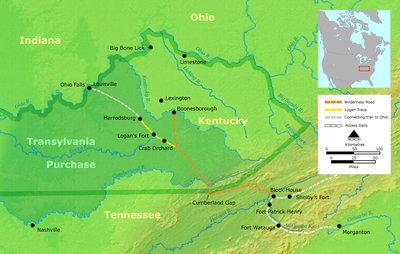
The Wilderness Road
Penn’s Pennsylvania enjoyed its own dealings with Native Americans, which exerted fundamental effects of the original political and settlement patters of that State. By the time the Early Republic commenced, Pennsylvania’s sphere of economic influence extended into Ohio, its migration flow intruded into the Appalachians, eventually into North Carolina, and then into Kentucky. Boone, a Pennsylvania born and raised Quaker, traveled on a road he forged (the Wilderness Road) entered Kentucky through the Cumberland Gap in 1775. Kentucky and Tennessee were culturally composite, but early, internal migrations.
Pennsylvania competed with Virginia, in northern North Carolina (West Virginia was part of Virginia in these years) and fused its western migration with Tidewater western migration [2]. Virginia’s George Washington, it might be remembered made his name with exploits in western Pennsylvania. All these shenanigans occurred in colonial times, but. Washington’s two administrations (1789-96) thoughtfully managed Indian Removal for these areas, setting up formal Early Republic policy toward Native American tribes (treaties, assimilation, and reservations–thank you Boston-born Henry Knox, his Secretary of War). When Jackson did the same in 1828-36, the matter was perceived somewhat differently.
As we discovered in our previous Mini-Series on the “Formation of the Cotton Belt“, Deep South internal migration, the expansion of the Cotton Empire, did not “really” begin until after the cotton gin’s invention (1794) and a generation after its diffusion and maturation. Up to that time, housed initially in the “Colony of Carolina”, Charleston and the nearby Lowlands hinterland, the Deep South branched out along the coast, Savannah in Georgia, and eastern North Carolina. It wasn’t until the Scots-Irish (post 1750) that North Carolina, Georgia and South Carolina internal settlement (into the Piedmont areas)–and a good deal of that as late as the 1780’s.
The Cotton Belt take off was after the 1814 Creek war and was most explosive during 1820-40–a generation after the Yankee Diaspora started. That is when serious Deep South Indian Removal commenced–gathering momentum until its apex with Jackson and its implementation resulting in the Trail of Tears (1840). By that time northern states were clearing Native Americans out of the Illinois area, paving the way for the birth and incredible growth of Chicago.
If there was a race to settle the interior, the North got a head start and by 1815 was well in the lead. The advantage proved temporary–but by 1840 the Yankee Diaspora reached into Oregon/Washington (the old “54-40 or fight”). When combined with factors discussed below, the case can be made that the need for DTIS lagged the North by a generation or so. When appropriate, antebellum South did employ External MED’s developmental transportation infrastructure strategy–successfully, it completed and opened the nation’s first commercial rail line in 1832–and that the South as a whole enjoyed some success in the 1850’s DTIS glory days.
Giving the Federal Government the Boot
In the antebellum period, roads could have done the DTIS job as well–but needed to be interstate to handle the migration. That’s a job better suited to the Federal Government. That did not work out, however, leaving the task of connecting Atlantic ports to the nation’s interior to the several states. Why that happened is worth a moment of our time.
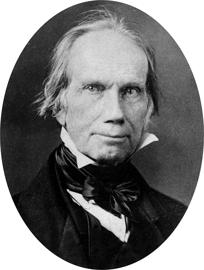
Henry Clay
As Two Ships, my published book, outlines the Feds effort to play a role in DTIS. It describes Henry Clay’s American System, and then tosses it aside by explaining that it ran afoul of that populist, Andrew Jackson. Clay was what came to be known as a Whig (a political party that in the Early Republic evolved into the Republican Party of Abraham Lincoln). Whigs advocated for a strong federal role in DTIS, but they were not able to capture the presidency after 1828, until Lincoln took office in 1861.
Jacksonian Democrats were in charge mostly during that interlude. They deeply opposed a federal role in what was called “internal improvements”–and shut down funding (and the National Bank) for these endeavors–which were already in execution. Jackson, we found out in Theme 2, tossed young Lincoln from his first job building a canal.
In Theme 2 we discovered George Washington, among other ED-related interests, was a “really big” canal enthusiast. He got the Federalist Party all lined up to tackle canal and road-building, but first had to concentrate on his own Indian-Removal campaign. It became murky politically after that, and after 1800 Thomas Jefferson booted the Federalists out and replaced them with his own Democrat-Republican Party. This is not the time to talk about Jefferson’s complex political thinking, but in terms of economic development, internal improvements and industrial-era financing, Jefferson was more congruent with our earlier described Tidewater political culture. He disliked banks–a lot–and strongly advocated for limited federal government and more active state governments. ED fell, in his mind, mostly to the latter.
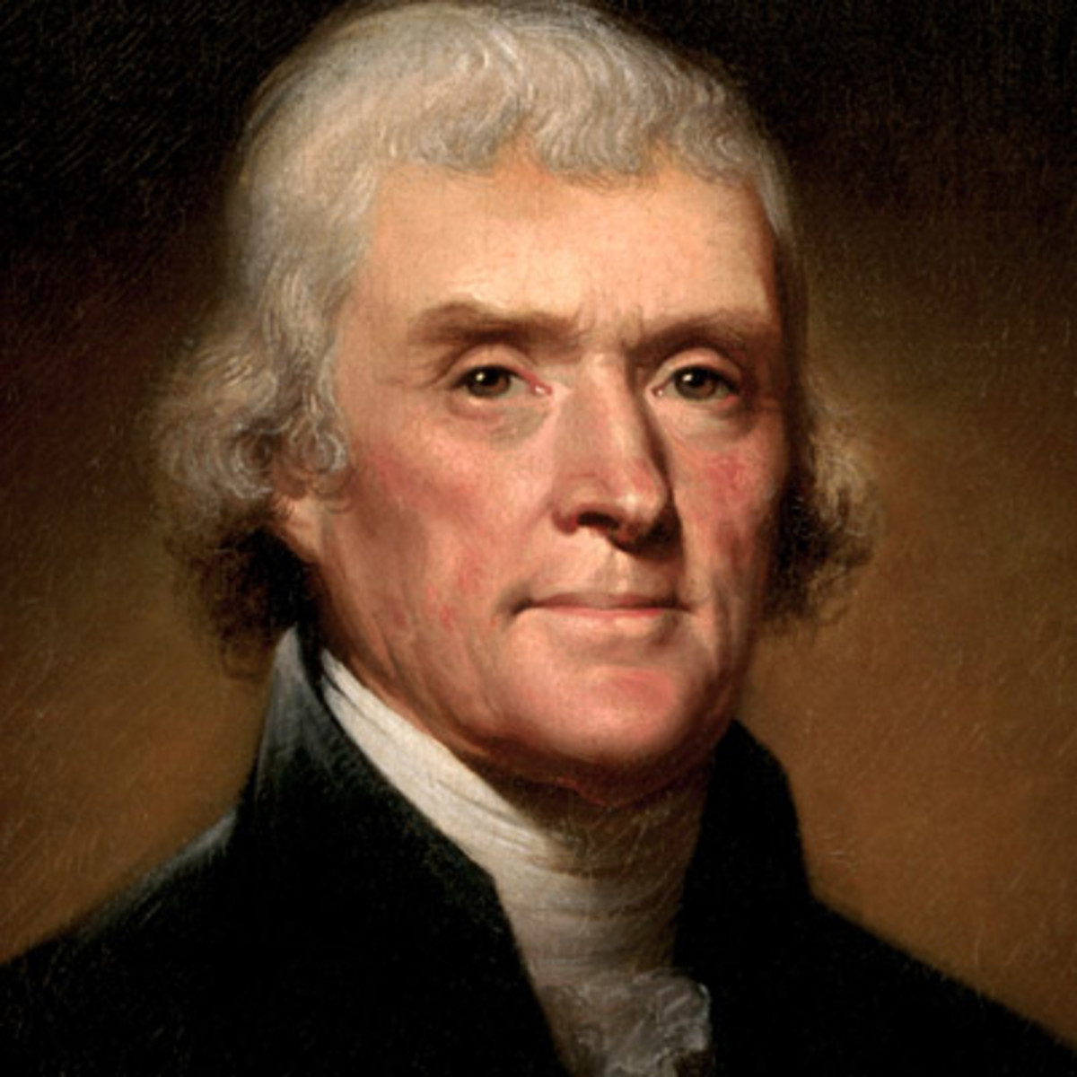
Thomas Jefferson
He shared with Washington a Tidewater faith in what has came to be called the “yeoman farmer”. That is a backdoor way of inserting his preference to use the federal government to develop an image of an American economy disproportionately based on agriculture.
Around 1800, that was not a preference that needs to be explained; it was the actual reality of our national economy at that time. The External MED task the Feds assumed in their minds was to get agricultural produce from the Big City hinterlands, and the American non-coastal states to Atlantic ports for use in Big Cities and export. That produce would be “manufactured” by homesteaders migrating to fertile western lands. Export was key to the Feds; the Feds financed their budget through export and import taxes.
Enter Albert Gallatin.
We first met Gallatin, a Swiss immigrant surveyor, when we talked about Washington’s ED exploits in Theme 2. In this module he was Jefferson’s Secretary of the Treasury. Gallatin, on his own dime, in 1808 developed what the American Planning Association, calls the first “national” infrastructure plan–arguably one of the earliest instances of American ED planning. Gallatin conceptualized this External MED strategy and expressed it on a map and narrative. He also identified funding (he was Sec. of the Treasury) and proposed a federally-financed road and canal program. In 1810 Henry Clay–the future author of the american System–was elected Speaker of the House of Representatives. The stars were all aligned.
Except they weren’t. Clay also wanted a war with Great Britain–War of 1812–and that ended any hope to spend federal money on “internal” infrastructure “improvements” for a heck of a long time.
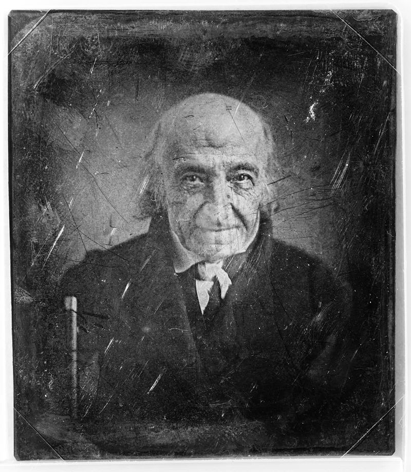
Amazing to have a “picture” of a man who in the 1780’s had supper in the wilds of Kentucky with George Washington
His plan, however, is worth a brief look. Essentially, Gallatin envisioned the creation of a national democracy anchored on a (1) planned settlement of the the continent (as he knew it) in which both politics and the economy was dominated by our so-called Jeffersonian yeoman farmers–small homestead farmers who provided food for their families, cities and for export. The External MED task was to get people and stuff to various points internally, and most of all to coastal ports for export. “Citizen-farmers would be connected to thriving cities and their world-wide markets by a federally-financed network of roads and canals“[3]. He identified four specific routes, linking Big City coastal ports of NYC, Philadelphia, Baltimore/Washington, and Charleston. He also outlined a series of coastal area canals that turned out remarkably like our present-day Atlantic Inter-coastal Canal.
Included in this was an abbreviated canal across a part of NY. That turned out (in 1826) to be the Erie Canal–a much longer canal than Gallatin conceptualized, but essentially he got that one right. His routes, however, intended for roads and canals, were adopted by railroad advocates when their technology defaulted into the new emerging technology gazelle of the 1830’s and after. That, as we shall see, proved unfortunate, but was no fault of long-dead Gallatin. But it does expose a problem with national plans: unanticipated technology and innovation.

the National Road
After Gallatin, pre-1828, the Feds approved the famous “National Road”–but it took forever to construct, and it did not connect directly to any coastal port. It did not end anywhere in particular–just where the money ran out–and therefore fell victim to the joke, “it started nowhere and ended no place”.
Feds did get involved in state canal-building, after the state-led/financed Erie Canal opened in 1826, mostly through land donations to the states. The Corp of Engineers commenced in this period as well–a story that will be told later. In the 1850’s I remind the reader, Stephen Douglas got the Feds behind our first transcontinental railroads (Theme 2).
Because of all this politics ebb and flow, because of the evolving modes of transportation, one can look at the Early Republic–and the South’s antebellum–Eras as being divided into two quite distinct DTIS phases: (1) the road, river improvements, and canal era until about 1832–internal improvements, and (2) the railroad era, after 1840 (with an overlapping transition period in between).
Imbalance in Number/Quality of Port Cities and the Appalachian “Barrier”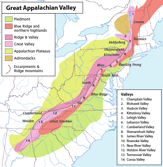
But the 800 lb. gorilla was the huge difference in topography between the two regions.
The Appalachians proved to be the more significant barrier to southern canals and railroads than in the North. There is a decided east-west (North) and north-south (South) river flow caused by Appalachian headwaters. From Virginia on down, mountains, particularly in central Blue Ridge/Smokies (southern Virginia, North/South Carolina, and Georgia) proved more significant barriers than their northern rivals.
Carter Goodrich observes “the steep and unbroken eastern wall of the Blue ridge, presented a particularly formidable obstacle to internal improvement. No railroad crossed this Appalachian barrier in this region until after 1880” [4] . When South Carolina Governor McDuffie announced in 1836 in his legislative message that South Carolina intended to cross over the Appalachian barrier by railroad to transform itself into the “New York of the South“ his External MED initiative was a more risky (and costly) decision than appreciated at the time.
As shall be discussed in the case studies, the Appalachian barrier’s physical dimension is often referred to as “the Fall Line”. The Fall Line horrendously complicated canals as a suitable southern internal improvement, and it affected railroads even more. Railroads could easily cope with the coastal lowlands and could reasonably manage the low rolling Piedmont. The rough Blue Ridge/Smokey mountains were another matter entirely–and the last two were above the Fall Line.
These areas were sparsely settled in the antebellum, were unsuitable for plantations and cotton belt expansion. They became bastions of yeoman hardscrabble farming, and attracted populations amenable to that employment and way of life. As such a cultural divide between lowlands and Piedmont which could embrace plantations and cotton, and highlands entered into this physical dimension. That will be important in our mini-study of Atlanta’s birth–her location is in the plateau-highlands, and Atlanta’s political culture reflected these realities. Georgian industrialization (textile mills, paper, and mining) found more “fertile ground” in these highland plateaus. That will also be apparent in our Knoxville case study.
Finally, alas given the carrying capacity of transportation technology in the antebellum period, the geographical barriers encountered by southern port cities–and two of the four northern port cities–were almost insurmountable (that’s a pun) in this time period. Cynically, New York City was able to win the race with agricultural-era transportation technology–Philadelphia, Baltimore, Savannah and Charleston lost it because industrial era railroad technology was not up to the task. It wasn’t innovation that won this race.
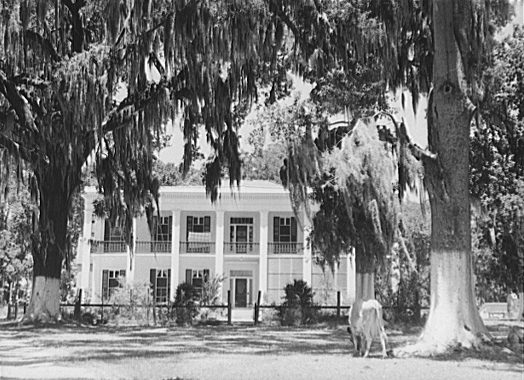
A Louisiana Plantation House–I know its also above–I like it
Capital Investment
The South’s core problem, however, was its informal/de facto decision or choice to develop an agricultural economic base, relegating industrialization to a secondary, if that, priority. The related decision to embrace cotton as its innovative gazelle-like crop-sector, and to create a Cotton Empire, which necessarily preserved a late medieval society, regressing to an ancient EDO (the Roman latifundia) with a mass-production slave-based plantation, as part of an essentially agricultural path into the 19th Century.
The business model, of the plantation weakened Southern already fragile investment and finance institutionalization, and diverted its capital accumulation into plantations/slaves and cotton, not infrastructure or industrialization. Cotton production, with a constant need for additional land to replace depleted soils, and a capital-intensive export economy did little to foster capital accumulation in the South. So did river-coastal port agricultural-plantation export economic base which tilted transportation routes to connect plantation hinterlands to the coast, rather than connect urban centers.
FDI was key to northern developmental infrastructure financing, but it played a much less prominent role in southern developmental infrastructure. They were then critically dependent on southern financial institutions and southern plantation-based wealth accumulation as the principal sources for developmental infrastructure financing. The latter, not a strong suit of the slave/plantation-based Cotton Empire. To the extent the South attracted FDI, it served agriculture and the Cotton Empire’s needs primarily.
The lack of southern urbanization meant rail lines were longer, and connected to “geographical trading points” not urban centers with their own needs and generated their own rail traffic. The dearth of immigrant travel, and the rural agricultural base limited southern railroad city-building–both of which deprived southern railroads of revenues and potential profits to pay off debt. In that railroads chief advantage in the Early Republic years was its speed, not cheapness, the lack of passenger travel disadvantaged southern railroad profitability.
Culture Affected Strategy Design and Policy Implementation

Southern External-MED was shaped by interplay between, and dynamics of, their distinctive southern Scots-Irish, Tidewater, and Deep South planter-dominated Cotton Empire cultures. While this Mini-Series focuses on railroads, the narrative constantly demonstrates how the complex and ever-shifting ebb and flow of their cultural clashes exerted a critically negative effect on banking, lending, and, therefore indirectly on the South’s capacity to amass capital for investment to finance developmental infrastructure.
If the aggregate of the southern political cultures resisted federal involvement with internal affairs, they were also never enthused about the state governments doing it either. Internal improvements, and railroad DTIS, almost always was triggered at the municipal level, by their business community. Southern political cultures also played a major role, not only in predisposing their adherents toward agriculture, but in stressing low tax, individual self-sufficiency, and limited government. The few sizable cities existing in the antebellum South meant the state alone could muster the resources needed for developmental transportation. Debt and banks were never southern antebellum favorites. The availability of capital in the North far exceeded the South’s–and it showed in DTIS implementation.
The cultures (with Tidewater more complex) shared belief in limited government, and very low tolerance for taxes, especially those perceived benefiting private elites–and no special regard for public-private partnerships–placed the South was at a distinct disadvantage to the North. Southern state budgets relied heavily on a slave tax, paid mostly by large plantation slaveholders, the planter class, who frequently were indifferent to railroad appeals proved to be a serious impediment railroad private-public partnerships. Local governments were the more consistent supporters of rail projects, but with limited fiscal resources, they were restricted to smaller projects and were less resilient to Panics and the price of cotton. Hence, Democrat vs. Whig internal improvement debate assumed a different texture in the South than it did the North. Whigs in the North did better in state legislatures, than in Democratic or machine-driven Big Cities. The opposite was more often true in the antebellum South.
Accordingly we will encounter state policy systems characterized by an indifferent planter class, and a distrusting, if not hostile “republican” Scots-Irish legislators that frequently dominated state policy systems. Whiggish internal improvements–and their state chartered corporations–were often perceived, in particular by Scots-Irish, as benefiting the rich elites, and potentially upsetting the stability of an agricultural society. DTIS got itself caught in the midst of an elite-common man dichotomy.
Only after the Panic of 1843 when economic growth was seen as the only way to pay off their debts, did the Scots-Irish fully subscribe to a robust DTIS. When the rare deviation from this policy dynamic occurred the result was dramatically different from the more common limited commitment to state level public-private partnerships. In these instances, the states themselves ran the project, isolating private business from the strategy.
The antebellum railroad age overlapped with Jacksonian populist ascendancy. At the core of Jackson’s larger view of “democracy” was Scots-Irish fundamental distrust of elites, and economic decisions made in faraway places. His fear that private institutions, reflecting elite interests, would potentially intrude into public decisions required policy systems responsible to this political culture to serve as a check on such “corruption”, by structurally ensuring they were closely accountable to the electorate.
Thus state and local government in antebellum Carolina needed to meet a series of potentially contradictory requirements. The electorate expected a government role in enhancing economic development, but wished such actions to be as unobtrusive as possible, both physically and fiscally. They desired that a government permit its citizens economic autonomy, yet demanded a high degree of popular control over private economic institutions…. In short, they wanted government to enhance their opportunities in a market society, while defending [its] participants from its pitfalls. And to do both on a parsimonious budget….
Despite a desire for government to play a part in their state’s development, South Carolinians still blanched at vast expenditures of public money or the creation of a vast, permanent administrative bureaucracy [5]
South Carolina’s political culture and its Early Republic policy system built in these two opposing tensions–strong and active government in internal improvements with a weak, fragmented, deeply accountable public process that above all checked elites and limited taxes. This will play out in South Carolina’s first “internal improvement initiative between 1816 and 1830. Planters might rule the economy and wealth creation, but the South Carolina policy system did not grant them anything close to complete dominance. In this contradictory dichotomy we can see the birth of the South’s, certainly South Carolina’s, famous-infamous low tax, low service policy system–and business climate.
South Carolina, the womb of America’s Cotton Empire, the principal driver behind the 19th century development of a southern agricultural economic base may seem a strange place to study industrialization’s cutting edge: developmental transportation infrastructure. As late as 1820, South Carolina had incorporated only five cities or towns, and contact between them was rude and rudimentary. But the choice of agriculture does not preclude developmental infrastructure, nor manufacturing and other forms of industrialization. Selecting South Carolina provides us an opportunity to see how the “Deep South” policy system conducted External-MED, and to what purposes it was put.
Overview of Southern Transportation Infrastructure
The North built canals at a rate far exceeding that of the South. Why? Investment capital availability, willingness of the state to form public-private ventures, and shorter intra-state canals that ran from city to city or connected factories to rivers. The South with a decided disadvantage in urbanization, disposable capital, and a political culture which stressed limited government lost that competition. Also, canals, the Erie Canal excepting, were vital to Early Republic water-powered industrial/manufacturing firms–not at all helpful to dispersed plantations and subsistence farmers.
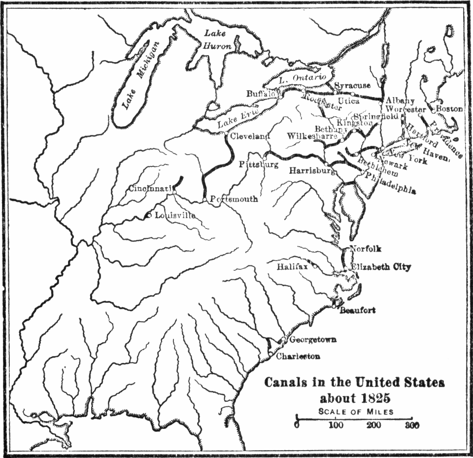
Operating Canals in 1825
The matter is further compounded by creating a decided difference between the regions in regards to mode of transportation possible before 1830: roads, canals, and steamboats. In this section I argue that geography made railroads too costly, if not ineffective, in this time period. It also allowed (because of the massive and centrally-placed Mississippi River) steamboats to be an effective substitute.
Canals, an agricultural era transportation technology around since ancient times, proved more cost-effective and until the mid-to-late Early Republic–providing geography permitted access into the interior. Only New York best enjoyed that advantage. New York alone could build a canal wholly within her own borders, and then through lake shipping and Midwest canals, penetrate deep into the emerging upper Midwest. Philadelphia missed that opportunity–it had a shot at making canals work–as it got off to a late, and confused, start. Thanks to Dewitt Clinton the Erie Canal was first on the block, and that canal worked well enough, long enough to do the job.
So when the age of railroads began, the North got off to a quicker start than the South. South Carolina won the race for the nation;s first-longest (1832–136 mile) rail line, but by 1840, the top three states in completed railroad mileage were Pennsylvania (625 miles), New York (363), and Massachusetts (305). Virginia (285) and Georgia (275) were 5th and 6th, with South Carolina 7th (204). By 1860 Illinois (2790), Pennsylvania (2598), and Indiana (2163) enjoyed the most rail mileage, with New York and Ohio neck and neck for 4th and 5th (2000+).
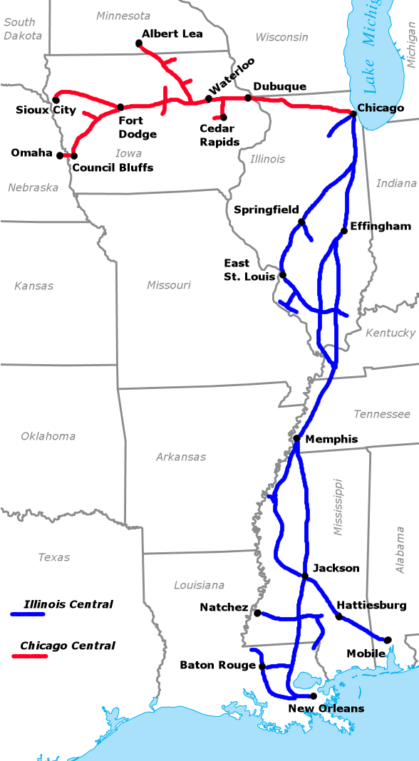
Illinois Central
Of southern states, Virginia (1731) was 6th, Georgia (1420) 7th, and Tennessee (1253) were the top three. Arkansas had 38, Texas (305), Louisiana (335), and Florida (402)–the western, and post-1840 Cotton Belt missed the railroad age almost entirely. The eastern Cotton Belt fared better with South Carolina (973), Mississippi (862), and Alabama (743)–but almost all of it occurred during the 1850’s. Stephen Douglas’s Illinois Central was also a big factor in the 1850’s southern rail renaissance, especially for Tennessee and Mississippi. [6].
Footnotes
[1] Gavin Wright, Old South, New South: Revolutions in the Southern Economy Since the Civil War (Louisiana State University Press, 1986), p. 4.
[1a] Two recent works have added to this analysis, providing useful perspective in evaluating the complex and double-edged role ‘Indian removal” played in American ED. James A. Warren, God, War and Providence (Scribner, 2018) and John Sedgwick, Blood Moon (Simon & Schuster, 2018)–which applies to our present case study as it alerts us to Jackson–Cherokee complexity in Indian removal described in this Module Series A.
[2] Not well known is that Daniel Boone, born and raised in Reading PA. by a Quaker (English-Welsh) family, had been expelled for religious reasons and set up housekeeping in North Carolina in 1751–when Danny-Boy was about seventeen. Virginia’s western movement is not included in this Online History; it should be added in the future. Until then, David Hackett Fischer and James C. Kelly’s, Bound Away: Virginia and the Westward Movement (2000) will have to suffice. Our Knoxville case study (Module 10) will also shed some light on Tennessee antebellum in migration.
[3] Robert Fishman, “Blueprint America the Next American System: 1808, 1908, 2008 National Planning for America, commissioned by the Regional Planning Association, and published by PBS and its America 2050 Initiative.
[4] Carter Goodrich, Government Promotion of American Canals and Railroads, 1800-1890 (1960), pp. 102-2
[5] Tom Downey, Planting a Capitalist South: Masters, Merchants, and Manufacturers in the Southern Interior, 1790-1860 (2006), p. 37.
[6] Clifford Thies, Development of the Railroad Network During the Early 19th Century. Independent Institute Working Paper Number 42, October 2001, p. 24, Table 3.